Content
Published:
This is an archived release.
Detached houses takes up most urban ground
More than one third of the land take in urban settlements is by areas of detached houses. Minor urban settlements demands more space, while larger ones builds in height. Close to one million employees works on 8 per cent of the total area of urban settlements. Less than one per cent of Norway's land area is covered by urban settlements.
Well above one third of the urban settlements area is used for detached houses and belonging gardens. This amounts to about half of the building near areas within urban settlements. Areas for multi-dwelling houses and row houses are small in comparison, and their proportion of the total urban area is largest in the greatest cities.
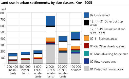
Over one fifth of the urban settlements remain unclassified. These areas are mostly results due to lacks in national map datasets. Unclassified areas consist mainly of parks and green belts, or are side area for traffic ores.
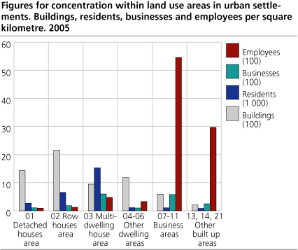
Efficient multi-dwellings and business areas
People live more densely in multi-dwelling areas than elsewhere in the cities. In average there are more than 15 000 residents per square kilometre in these areas. Equivalently there are about 2 600 and 6 500 inhabitants per in areas for detached houses and row houses. However, far more people live in detached houses areas, about 1.4 million persons.
Business areas are also efficient measured by number of businesses and employees per square kilometre. In average close to 600 businesses and nearly 5 500 employees are located per square kilometre. This implies that 38 and 63 per cent of the businesses and employees are concentrated to 8 per cent of the total area of the urban settlements. Roughly 30 per cent of the businesses and less than 5 per cent of the employees are located to areas of detached houses.
Irreversible changes
One quarter of the urban settlements consist of physically built-up areas for transport ores and buildings. Built up areas for communication (roads, railways and airports) take about 350 square kilometres (see the table), or 15.9 per cent of the total urban areas. Buildings take over 200 square kilometres. In addition comes amongst others parking and harbour areas which is not caught by the statistics. Physical built up areas is often thought of as none-reversible land use changes, where the soils quality for agriculture and drainage is strongly reduced.
| Area and land use in urban settlements. Whole country. 2005 |
| Area i km2 | Land use | ||||||||||||||||||||||||||||||||||||||
|---|---|---|---|---|---|---|---|---|---|---|---|---|---|---|---|---|---|---|---|---|---|---|---|---|---|---|---|---|---|---|---|---|---|---|---|---|---|---|---|
| In all |
Hereoff
communi- cation |
Hereoff
buildings |
Hereoff
in edge* |
Buildings (N) | Residents (N) | Businesses (N) | Employees (N) | ||||||||||||||||||||||||||||||||
| In all | 2 219.2 | 352.7 | 216.1 | 244.6 | 1 690 192 | 3 560 133 | 273 575 | 1 571 192 | |||||||||||||||||||||||||||||||
| 01 Detached houses area | 811.8 | 137.5 | 107.8 | 47.7 | 1 161 904 | 2 160 145 | 82 281 | 71 816 | |||||||||||||||||||||||||||||||
| 02 Row houses area | 60.0 | 10.3 | 12.8 | 1.8 | 129 214 | 389 806 | 10 856 | 7 160 | |||||||||||||||||||||||||||||||
| 03 Multi-dwelling house area | 29.4 | 4.4 | 8.0 | 0.5 | 27 727 | 448 158 | 17 546 | 14 088 | |||||||||||||||||||||||||||||||
| 04 -06 Other dwelling areas | 78.6 | 12.6 | 6.8 | 14.5 | 92 190 | 86 476 | 7 814 | 25 531 | |||||||||||||||||||||||||||||||
| 07 - 11 Business areas | 181.8 | 18.8 | 48.2 | 22.3 | 106 678 | 182 993 | 104 724 | 992 084 | |||||||||||||||||||||||||||||||
| 12, 15 - 19 Recrational and green areas | 520.7 | 41.4 | 10.6 | 147.6 | 68 082 | 71 713 | 8 119 | 50 259 | |||||||||||||||||||||||||||||||
| 13, 14, 21 Other built up areas | 72.7 | 49.0 | 8.0 | 10.2 | 14 580 | 59 241 | 18 143 | 216 097 | |||||||||||||||||||||||||||||||
| 99 Unclassified | 464.3 | 78.6 | 13.9 | 93.7 | 89 817 | 161 601 | 24 092 | 194 157 | |||||||||||||||||||||||||||||||
| * | The edge is a 15 meter wide belt from the outer limit of the urban settlement and inwards. |
Urban settlements cover less than 1 per cent of the country's land area, but 16.5 per cent of built up areas for communication is situated within the urban settlements. Roads cover more than 100 square kilometres of areas for detached houses.
About data sources and uncertainty
Statistics for land use in urban settlements is based upon information about buildings in the Ground property, Address and Building register (GAB), figures for businesses and employees in the geo-referenced business register (BR), figures for residents in the central population register (CPR), map datasets for roads (VBASE) and national land cover maps in scale of 1:50 000 (N50).
Figures are preliminary and do have uncertainty. Uncertainty in register based area figures is mainly due to a variable quality and quantity of the information on area in GAB. Uncertainty related to businesses and employees are due to missing information on exact geographical location. The proportion of unclassified areas can be explained by lacks in the classification system for mapping.
Contact
-
Margrete Steinnes
E-mail: margrete.steinnes@ssb.no
tel.: (+47) 95 73 55 54
-
Svein Johan Reid
E-mail: sjr@ssb.no
tel.: (+47) 41 51 29 66