Content
Published:
This is an archived release.
One in four lives in the four largest urban areas
New estimates show that on 1 January 1999, 28.1 per cent of Norways population was living in the countrys four largest urban areas: Oslo, Bergen, Stavanger/Sandnes and Trondheim. Altogether 76.7 per cent of the population lived in 910 urban settlements covering just over 2 084 km2.
Although three out of four people in Norway live in urban settlements, only the four largest urban settlements have more than 100 000 inhabitants. In addition to these, 15 have more than 20 000, 314 between 1 000 and 20 000, while all of 578 urban settlements have less than 1 000 residents. By Statistics Norways definition an urban settlement is, somewhat simplified, a place with at least 200 residents where the distance between houses is generally not more than 50 metres.
| Urban settlements. Population, population density and area. 1 January 1999 |
| Size class. Population | Number of urban settlements | Population | Population density per km² | Total urban settlement area. km² | Per cent of urban settlement area | ||||||||||||||||||||||||||||||||||
|---|---|---|---|---|---|---|---|---|---|---|---|---|---|---|---|---|---|---|---|---|---|---|---|---|---|---|---|---|---|---|---|---|---|---|---|---|---|---|---|
| Covered by buildings | Covered by roads | ||||||||||||||||||||||||||||||||||||||
| The whole country | 1911 | 3 304 352 | 1 585 | 2 084,3 | 7,6 | 15,1 | |||||||||||||||||||||||||||||||||
| 200 - 499 | 359 | 120 848 | 728 | 166,0 | 5,3 | 14,5 | |||||||||||||||||||||||||||||||||
| 500 - 999 | 219 | 150 806 | 836 | 180,4 | 5,6 | 15,2 | |||||||||||||||||||||||||||||||||
| 1 000 - 1 999 | 143 | 205 059 | 1 007 | 203,7 | 6,1 | 15,3 | |||||||||||||||||||||||||||||||||
| 2 000 - 19 999 | 171 | 897 656 | 1 353 | 663,5 | 7,3 | 15,5 | |||||||||||||||||||||||||||||||||
| 20 000 - 99 999 | 15 | 681 168 | 1 702 | 400,2 | 8,2 | 15,7 | |||||||||||||||||||||||||||||||||
| 100 000 - | 4 | 1 248 815 | 2 654 | 470,6 | 10,0 | 13,9 | |||||||||||||||||||||||||||||||||
| 1 | Corrected 20.12.2000. |
Varying density
On 1 January 1999, the population of the urban settlement of Oslo, which stretches over 266 km2 in 11 municipalities and 3 counties, was 764 000, 2 900 persons per square kilometre. Population density per km2 was about 2 400 in Bergen, 2 300 in Stavanger/Sandnes and 2 400 in Trondheim. The average for all urban settlements was 1 585 residents per km2.
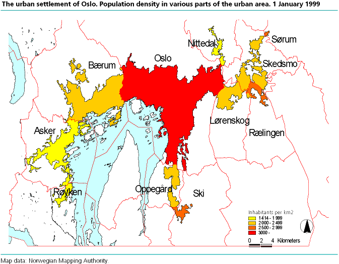
Population density varies considerably within urban settlements. In the urban settlement of Oslo, the population was the densest in the area within the City of Oslo proper, with 3 800 residents per km2. In the parts of urban Oslo belonging to other municipalities, the population density varied between 2 600 persons per km2 in Rælingen municipality to barely 1 500 per km2 in Røyken municipality.
Buildings and roads
Buildings accounted for 7.6 per cent and roads for 15.1 per cent of the land area in Norways urban settlements. The calculation was made on the basis of building areas registered in the Ground Property, Address and Building Register (GAB) and digital map data from the Norwegian Mapping Authority. Both population density and percentage of built-on land in the urban settlements show a tendency to decrease with decreasing size of the urban settlement, although this pattern is not consistent because of large variations in land utilization in the size groups.
Increase in area since 1990
Past calculations of urban settlement areas show that the total area of the 19 urban settlements with at least 20 000 residents in 1999 increased by 7.6 per cent in the course of nine years, from 811 km2 on 1 January 1990 to 873 km2 in 1999. In the same urban settlements the proportion of the urban settlement area covered by buildings increased from 8.5 per cent in 1990 to 9.1 per cent in 1999. The density of building stocks has thus increased by 0.6 percentage point.
| Urban settlements with more than 20 000 inhabitants. 1 january 1990 and 1999 |
| Urban settlement | 1. januar 1999 | 1. januar 1990 | |||||||||||||||||||||||||||||||||||||
|---|---|---|---|---|---|---|---|---|---|---|---|---|---|---|---|---|---|---|---|---|---|---|---|---|---|---|---|---|---|---|---|---|---|---|---|---|---|---|---|
| Population in urban settlements | Population density per km² | Total urban settlement area. km² | Of which | Total urban settlement area. km² | Of which | ||||||||||||||||||||||||||||||||||
| Area of buildings | Area of roads | Area of buildings | |||||||||||||||||||||||||||||||||||||
| All urban settlements in the country | 3 304 352 | 1 585 | 2 084,3 | 159,8 | 315,0 | : | : | ||||||||||||||||||||||||||||||||
| OSLO | 763 957 | 2 874 | 265,8 | 26,6 | 33,5 | 250,9 | 23,1 | ||||||||||||||||||||||||||||||||
| BERGEN | 203 383 | 2 400 | 84,7 | 8,9 | 15,1 | 78,1 | 7,9 | ||||||||||||||||||||||||||||||||
| STAVANGER/SANDNES | 142 937 | 2 299 | 62,2 | 7,1 | 9,9 | 57,9 | 5,8 | ||||||||||||||||||||||||||||||||
| TRONDHEIM | 138 538 | 2 396 | 57,8 | 4,4 | 6,9 | 55,1 | 3,8 | ||||||||||||||||||||||||||||||||
| FREDRIKSTAD/SARPSBORG | 91 749 | 1 483 | 61,9 | 5,4 | 9,2 | 56,6 | 4,8 | ||||||||||||||||||||||||||||||||
| DRAMMEN | 82 955 | 1 809 | 45,9 | 3,8 | 7,5 | 40,8 | 3,1 | ||||||||||||||||||||||||||||||||
| PORSGRUNN/SKIEN | 82 612 | 1 571 | 52,6 | 3,6 | 7,6 | 50,5 | 3,3 | ||||||||||||||||||||||||||||||||
| KRISTIANSAND | 60 350 | 2 121 | 28,9 | 2,5 | 4,6 | 25,9 | 2,2 | ||||||||||||||||||||||||||||||||
| TROMSø | 48 179 | 2 310 | 20,9 | 1,8 | 3,5 | 16,5 | 1,4 | ||||||||||||||||||||||||||||||||
| TøNSBERG | 42 702 | 1 463 | 29,2 | 2,3 | 4,5 | 27,7 | 2,0 | ||||||||||||||||||||||||||||||||
| HAUGESUND | 38 224 | 1 788 | 21,4 | 1,9 | 4,0 | 19,0 | 1,6 | ||||||||||||||||||||||||||||||||
| SANDEFJORD | 36 527 | 1 503 | 24,3 | 1,6 | 3,7 | 22,1 | 1,4 | ||||||||||||||||||||||||||||||||
| åLESUND/SPJELKAVIK | 35 037 | 1 675 | 20,9 | 1,8 | 3,2 | 19,7 | 1,6 | ||||||||||||||||||||||||||||||||
| MOSS | 32 335 | 2 040 | 15,8 | 1,3 | 2,3 | 15,2 | 1,1 | ||||||||||||||||||||||||||||||||
| BODø | 30 452 | 2 349 | 13,0 | 1,2 | 2,3 | 11,8 | 0,9 | ||||||||||||||||||||||||||||||||
| ARENDAL | 29 798 | 1 251 | 23,8 | 1,5 | 3,4 | 21,5 | 1,3 | ||||||||||||||||||||||||||||||||
| HAMAR | 27 234 | 1 676 | 16,3 | 1,7 | 2,8 | 15,7 | 1,5 | ||||||||||||||||||||||||||||||||
| LARVIK | 21 940 | 1 691 | 13,0 | 1,3 | 2,2 | 12,0 | 1,1 | ||||||||||||||||||||||||||||||||
| HALDEN | 21 074 | 1 690 | 12,5 | 1,0 | 2,0 | 11,9 | 0,9 | ||||||||||||||||||||||||||||||||
Quality
The urban settlement statistics from 1999 are based on results of linkages between the National Population Register (DSF) and the GAB. With the use of numerical addresses, address/building coordinates and a geographic information system (GIS), buildings and associated population are grouped into urban settlements. The quality of the statistics will depend at any given time on the completeness and accuracy of the location data in the registers. For 1999, it was possible to connect 97 per cent of the population to a residential address. From an overall perspective, this provides acceptable values as a basis for authoritative population and land area statistics for most urban settlements. Greater uncertainty is associated with calculation of building and road areas, and calculation of urban settlement areas and population in 1990.
Tables:
- Table 1 Urban settlements. Population and area by municipalities. Revised figures. 1 January 1999
- Table 2 Population and area in urban settlements. Municipality. 1 January 1999. Revised figures
- Table 3 Area and land cover in urban settlements. Municipality. 1 January 1999. Revised figures
- Table 4 Population in densely and sparsely populated areas. Municipality. Revised figures. 1 January 1999
Contact
-
Even Høydahl
E-mail: even.hoydahl@ssb.no
tel.: (+47) 95 77 79 06
-
Dana Moe
E-mail: dana.moe@ssb.no
tel.: (+47) 99 85 23 42
-
Vilni Verner Holst Bloch
E-mail: vilni.verner.holst.bloch@ssb.no
tel.: (+47) 94 82 25 32
-
Statistics Norway's Information Centre
E-mail: informasjon@ssb.no
tel.: (+47) 21 09 46 42