Content
Published:
This is an archived release.
More building on the shore
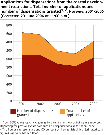
72 per cent of the applications for dispensation in the shore zone was granted during 2005,close to the same as the previous year. But the number of applications has increased noticeably. It is around the big cities the density of applications as well as the proportion of developed shore zone, are highest.
§ 17-2 of the Planning and Building act is restricting developments in the shore zone. Aside from designated areas in municipal land use plans, building and development has to be carried out through dispensations. Most dispensation applications where granted in 2005 according to the KOSTRA reporting. The number of granted dispensations per kilometer shoreline is 5 times higher in central areas compared to the less central, even though a smaller part of the applications are granted in the central areas
The proportion of the shoreline less than 100 metres from buildings, are higher north of Hordaland. The municipalities along the coast from Østfold to Hordaland are somewhat more restrictive than the municipalities further north. During the period 2001-2005, 1,4 dispensations were granted per 10 kilometer of shoreline (outside of urban agglomerations) for Hordaland-Østfold, while the number was 0,3 north of Hordaland.
Objections to regulation-plans
The figures for dispensations represent the building activity that is not included in municipal land use plans. In addition to building activity by dispensations, building activity also happens as part of the ordinary land use plans in the shore zone. Through the KOSTRA statistical system we obtain the number of land use plans or regulations which are met with objection from higher authority. 19 per cent of all objections (118) were due to the shore zone.
| Number of objections to regulation-plans put forward with consideration to the shore zone, by objection authority. 2005 |
| The county council | The county governor | ||||||||||||||||||||||||||||||||||||||
|---|---|---|---|---|---|---|---|---|---|---|---|---|---|---|---|---|---|---|---|---|---|---|---|---|---|---|---|---|---|---|---|---|---|---|---|---|---|---|---|
| The whole country 1 | 18 | 100 | |||||||||||||||||||||||||||||||||||||
| The shoreline østfold-Vest-Agder | 5 | 29 | |||||||||||||||||||||||||||||||||||||
| Rogaland and Hordaland | 2 | 35 | |||||||||||||||||||||||||||||||||||||
| The rest of the country | 11 | 36 | |||||||||||||||||||||||||||||||||||||
| 1 | Around 90 per cent of the municipalities reported. |
Important terms The shore zone is the area less than 100 metres from the shoreline measured in the horizontal plane. The term "developed shoreline" is defined as areas where buildings exist in the adjacent shore zone. The portion of developed shoreline has been calculated on basis of the official register for Ground Properties, Addresses and Buildings (GAB), and the shoreline from the map series N50, digital data from maps in the scale 1:50 000. Both of these data sources are developed and administrated by the Norwegian Mapping Authority. The calculations of development over time, have been done on basis of the "date of first use" for new buildings. Annexes and extensions have not been counted/defined as changes. |
Targets and key figures for the environmental policy
Everyone shall have the opportunity to take part in outdoor recreation as a healthy and environmental sound leisure activity that provides a sense of well - being , both near their homes and in the countryside . This is the strategic objective for the target outdoor life in the Norwegian environmental policy. In this aspect the shore zone is very valuable, offering opportunities for outdoor recreation. At the same time these areas are under great pressure from developments that are restricting the public access to the areas.
Several key indicators have been defined as a tool for supervising the development in the national environmental targets as outlined in White Paper no 25 from the Storting (Stortingsmelding no. 25 (2002-2003)). Access to the shore zone is one of the key indicators.
The shoreline of the Norwegian mainland is 83,281 km, counting islands, fjords and bays. This corresponds to more than twice the Earth's circumference at equator. Most of the urban settlements and a large part of the developed areas, including weekend and holiday homes, are situated along the coast.
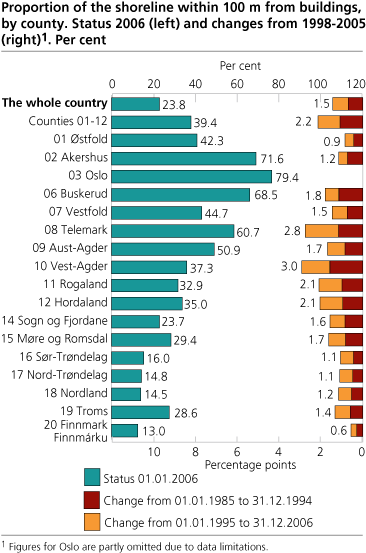
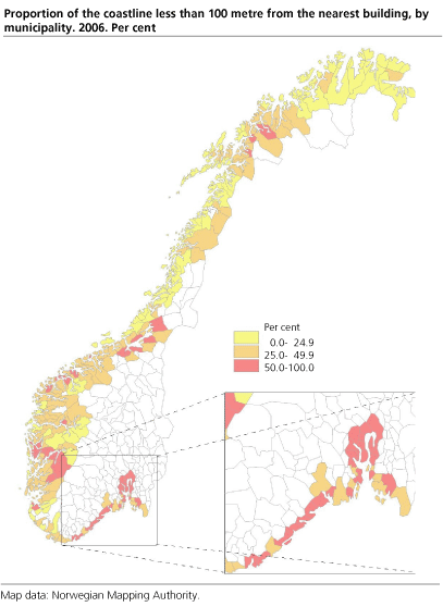
23.8 per cent of the shoreline
It is a national objective that valuable areas for outdoor recreation should be protected. Despite this - there has been some development of the shore zone. For the country as a whole 23.8 per cent of the shoreline is less than 100 meters from the nearest building (As registered in GAB 01.01.2006) Concerning the coast from Østfold to Hordaland, which is given particular attention in environmental policy, as much as 39.4 per cent of the shoreline is less than 100 meters from the nearest building. This indicates that the public access to the shore zone may be severely restricted in some areas. The developed shore zone is found in particular by the larger urban settlements and by concentrations of weekend and holiday homes. The municipalities situated in the inner parts of the Oslo fjord, have the largest portion of developed shoreline.
Highest pressure around the large cities
The highest proportion of shoreline less than 100 metres from buildings, are in and around the large cities. The results are presented by centrality. That is, each municipality in Norway has been classified according to travel time to the closest urban settlement over a certain size. The central municipalities have more of the shoreline influenced by buildings than less central municipalities. 39.1 per cent of the shoreline in the central municipalities is less than 100 metres from a building, while the corresponding figure for the least central municipalities are 17.6 per cent. Also in the time period from 1985 to 2006, the building activity has been higher in more central municipalities compared to less central municipalities. Granted dispensation applications are also densest in the central areas.
More developed in the mainland
A higher share of the shoreline (islands with bridge or tunnel to the mainland included) was within 100 metres from buildings in the mainland as compared to islands. 37.9 per cent of the mainland shoreline was influenced by buildings. The development in the period 1985 - 2006 was also faster in the mainland (2.4 percentage points increase). Of the mainland shoreline in the counties from Østfold to Hordland, 53.9 per cent had buildings within 100 metres.
Buildings and residents in the shore zone
As of January 1. 2006 there was 447 000 buildings within 100 meters from the shoreline (all islands included1), this represents 12 per cent of all buildings in Norway. 110 000 of the buildings was dwellings, 80 000 was holiday homes, 175 000 boat-houses or garages and 83 000 other buildings. There was 280 000 residents within the shore zone as of January 1. 2006.
1 Previously published figures comprised the mainland only.
Tables:
Contact
-
Tom Anders Engebakken
E-mail: tom.engebakken@ssb.no
tel.: (+47) 47 46 47 66
-
Jørn Kristian Undelstvedt
E-mail: jorn.kristian.undelstvedt@ssb.no
tel.: (+47) 94 50 68 64