Content
Published:
This is an archived release.
Still high proportion of dispensations
74 per cent of the applications for dispensation in the coastal zone were granted during 2004. This is the same proportion as the previous year while the number of applications has decreased somewhat. Around 0.1 per cent or 60 km of the coastline has changed from unexposed to being exposed by building activity during 2004.
The figures are based on reports from the municipalities through the KOSTRA (municipalities to the state reporting) supplemented by calculations based on the national administrative register of buildings (GAB).
Most dispensation applications are granted
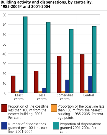
§ 17-2 of the Planning and Building act are restricting developments in the coastal zone. Aside from designated areas in municipal land use plans, building and development has to be carried out through dispensations. Most dispensation applications where granted in 2004 according to the KOSTRA reporting. The number of granted dispensations per kilometer coastline is 5 times higher in central areas compared to the less central, even though a smaller part of the applications are granted in the central areas
| Proportion of applications of dispensations from the development restrictions that was granted or rejected. The whole country, the coast from østfold-Hordaland and the coast from Sogn og Fjordane-Finnmark Finnmárku. 2001-2004. Per cent |
| Number of applications | Proportion of applications granted. Per cent | ||||||||||||||||||||||||||||||||||||||
|---|---|---|---|---|---|---|---|---|---|---|---|---|---|---|---|---|---|---|---|---|---|---|---|---|---|---|---|---|---|---|---|---|---|---|---|---|---|---|---|
| 2001 | 2002 | 20031 | 2004 | 2001 | 2002 | 20031 | 2004 | ||||||||||||||||||||||||||||||||
| The whole country | 1 622 | 1 570 | 1 175 | 1 084 | 67 | 69 | 74 | 74 | |||||||||||||||||||||||||||||||
| The coast østfold to Hordaland | 1 071 | 1 016 | 676 | 617 | 62 | 65 | 66 | 68 | |||||||||||||||||||||||||||||||
| The coast Sogn og Fjordane to Finnmark Finnmárku | 551 | 554 | 499 | 467 | 79 | 76 | 84 | 81 | |||||||||||||||||||||||||||||||
| østfold | 85 | 97 | 45 | 53 | 75 | 68 | 71 | 60 | |||||||||||||||||||||||||||||||
| Akershus | 41 | 23 | 30 | 8 | 49 | 65 | 63 | 63 | |||||||||||||||||||||||||||||||
| Oslo | 0 | 0 | 0 | 0 | . | . | . | . | |||||||||||||||||||||||||||||||
| Buskerud | 14 | 24 | 2 | 0 | 64 | 21 | 0 | . | |||||||||||||||||||||||||||||||
| Vestfold | 86 | 161 | 42 | 18 | 59 | 66 | 74 | 67 | |||||||||||||||||||||||||||||||
| Telemark | 118 | 96 | 44 | 29 | 48 | 43 | 32 | 69 | |||||||||||||||||||||||||||||||
| Aust-Agder | 206 | 121 | 85 | 62 | 56 | 72 | 76 | 73 | |||||||||||||||||||||||||||||||
| Vest-Agder | 142 | 149 | 89 | 85 | 73 | 67 | 65 | 65 | |||||||||||||||||||||||||||||||
| Rogaland | 103 | 106 | 100 | 87 | 43 | 52 | 56 | 62 | |||||||||||||||||||||||||||||||
| Hordaland | 276 | 239 | 239 | 275 | 70 | 76 | 73 | 72 | |||||||||||||||||||||||||||||||
| Sogn og Fjordane | 129 | 89 | 73 | 46 | 81 | 79 | 81 | 85 | |||||||||||||||||||||||||||||||
| Møre og Romsdal | 124 | 135 | 123 | 127 | 72 | 72 | 85 | 73 | |||||||||||||||||||||||||||||||
| Sør-Trøndelag | 71 | 66 | 34 | 37 | 82 | 80 | 100 | 73 | |||||||||||||||||||||||||||||||
| Nord-Trøndelag | 38 | 41 | 31 | 37 | 79 | 63 | 68 | 92 | |||||||||||||||||||||||||||||||
| Nordland | 96 | 119 | 110 | 121 | 80 | 80 | 78 | 86 | |||||||||||||||||||||||||||||||
| Troms | 71 | 83 | 122 | 78 | 83 | 82 | 89 | 79 | |||||||||||||||||||||||||||||||
| Finnmark Finnmárku | 22 | 21 | 6 | 21 | 73 | 52 | 100 | 90 | |||||||||||||||||||||||||||||||
| 1 | From 2003 onwards only dispensations regarding new buildings are reported. Reporting for previous years comprised all dispensations in the shore zone. We received reports from somewhat more than 90 per cent of the municipalities. |
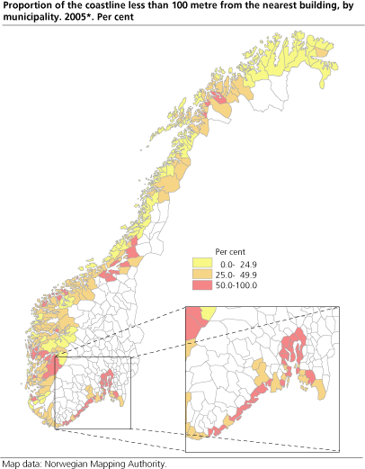
The proportion of the coastline less than 100 metres from buildings, are higher north of Hordaland (table 1). The municipalities along the coast from Østfold to Hordaland are somewhat more restrictive than the municipalities further north. During the period 2001-2004, 0,9 dispensations were granted per 10 kilometer of coastline for Hordaland-Østfold, while the number was 0,3 north of Hordaland.
|
Important terms
The shore zone is the area less than 100 metres from the shoreline measured in the horizontal plane. The term "developed coastline" is defined as areas where buildings exist in the adjacent shore zone. The portion of developed coastline has been calculated on basis of the official register for Ground Properties, Addresses and Buildings (GAB), and the coastline from the map series N50, digital data from maps in the scale 1:50 000. Both of these data sources are developed and administrated by the Norwegian Mapping Authority. The calculations of development over time, have been done on basis of the "date of first use" for new buildings. Annexes and extensions have not been counted/defined as changes. |
Targets and key figures for the environmental policy
Everyone shall have the opportunity to take part in outdoor recreation as a healthy and environmental sound leisure activity that provides a sense of well-being, both near their homes and in the countryside. This is the strategic objective for the target outdoor life in the Norwegian environmental policy. In this aspect the coastal zone is very valuable, offering opportunities for outdoor recreation. At the same time these areas are under great pressure from developments that are restricting the public access to the areas.
Several key indicators have been defined as a tool for supervising the development in the national environmental targets as outlined in White Paper no 25 from the Storting (Stortingsmelding no. 25 (2002-2003)). Access to the coastal zone is one of these key indicators.
The coastline of the Norwegian mainland is 83,281 km, counting islands, fjords and bays. This corresponds to more than twice the Earth's circumference at equator. Most of the urban settlements and a large part of the developed areas, including weekend and holiday homes, are situated along the coast.
The national objective in danger?
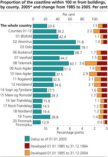
It is a national objective that valuable areas for outdoor recreation should be protected. Despite this - there has been some development of the coastal zone. For the country as a whole 23.6 per cent of the coastline is less than 100 meters from the nearest building (As registered in GAB 01.01.2005) Concerning the coast from Østfold to Hordaland, which is given particular attention in environmental policy, as much as 39.2 per cent of the coastline is less than 100 meters from the nearest building. This indicates that the public access to the coastal zone may be severely restricted in some areas. The developed coastal zone is found in particular by the larger urban settlements and by concentrations of weekend and holiday homes (figure 1 and 2).
The municipalities situated in the inner parts of the Oslo fjord, have the largest portion of developed coastline. The urban settlement of Oslo, is occupying a considerable proportion of these areas.
Highest pressure around the large cities
The highest proportion of coastline less than 100 metres from buildings are in and around the large cities. The results are presented by centrality. That is, each municipality in Norway has been classified according to travel time to the closest urban settlement over a certain size. The central municipalities have more of the coastline influenced by buildings than less central municipalities. 39.3 per cent of the coastline in the central municipalities is less than 100 metres from a building, while the corresponding figure for the least central municipalities are 17.4 per cent. Also in the time period from 1985 to 2005, the building activity has been higher in more central municipalities compared to less central municipalities. Granted dispensation applications are also densest in the central areas.
More developed in the mainland
A higher share of the coastline was within 100 metres from buildings in the mainland as compared to islands. 38.6 per cent of the mainland coastline was influenced by buildings. The development in the period 1985 - 2005 was also faster in the mainland (2.3 percentage points increase). Of the mainland coastline in the counties from Østfold to Hordland, 54.6 per cent had buildings within 100 metres.
Buildings and residents in the coast zone
As of January 1. 2005 there was 254 500 buildings within 100 meters from the coastline, this represents 7 per cent of all buildings in Norway. 63 000 of the buildings was dwellings, 44 500 was holiday homes, 96 500 boat-houses or garages and 51 000 other buildings. Of all the buildings in the coast zone 32 per cent was inside urban agglomerations (81 000). There was 166 500 residents within the coast zone as of January 1. 2005.
Contact
-
Tom Anders Engebakken
E-mail: tom.engebakken@ssb.no
tel.: (+47) 47 46 47 66
-
Jørn Kristian Undelstvedt
E-mail: jorn.kristian.undelstvedt@ssb.no
tel.: (+47) 94 50 68 64