Content
Published:
This is an archived release.
Still building activity in shore zones
Almost one fourth of the Norwegian coastline is affected by buildings and development. 1.4 per cent of previous unaffected coastline, corresponding to 1 166 km, has been subject to development in the period from 1985 to 2003. The undeveloped coastline from Østfold to Hordaland has been reduced by 2.4 per cent, or 492km in the same period. For this area 38.8 per cent of the coastline is now developed.
|
Important terms
The shore zone is the area less than 100 metres from the shoreline measured in the horizontal plane. The term "developed coastline" is defined as buildings in the adjacent shore zone. The portion of developed coastline has been calculated on basis of the official register for Ground-properties, Addresses and Buildings (GAB), and the coastline from the map series N50, digital data from maps in the scale 1:50 000. Both of these data sources are developed and administrated by the Norwegian Mapping Authority. The calculations of development over time, have been done on basis of the "date of first use" for new buildings. Annexes and extensions have not been counted/defined as changes.] |
Everyone shall have the opportunity to take part in outdoor recreation as a healthy and environmental sound leisure activity that provides a sense of well - being , both near their homes and in the countryside . This is the strategic objective for outdoor life in the Norwegian environmental policy. In this aspect the coastal zone is very valuable, offering opportunities for outdoor recreation. At the same time these areas are under a great pressure from developments that are restricting the public access to the areas.
Several key indicators have been defined as a tool for supervising the development in relation to the national environmental targets as given in Stortingsmelding no. 25 (2002-2003). Access to the coastal zone is one of these key indicators.
The coastline of the Norwegian mainland is 83,281 km, counting islands, fjords and bays. This corresponds to more than twice the Earth's circumference at equator. Most of the urban settlements and a large part of the developed areas, including weekend and holiday homes, are situated along the coast.
The national objective in danger?
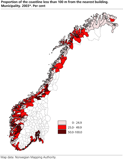
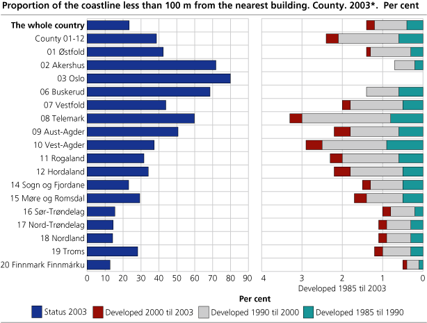
It is a national objective that valuable areas for outdoor recreation should be protected. Despite this there has been some development of the coastal zone. For the country as a whole 23.4 per cent of the coastline counting also all islands is less than 100 metres from the nearest building (As registered in GAB 01.01.2003) This corresponds to halfway around equator. Concerning the coast from Østfold to Hordaland, which is given particular attention in environmental policy, as much as 38.8 per cent of the coastline is less than 100 metres from the nearest building. This indicates that public access to the coastal zone can be severely restricted in some areas. The developed coastal zone is found in particular by the larger urban settlements and by concentrations of weekend and holiday homes (figure 1 and 2).
The municipalities situated in the inner parts of the Oslo fjord, have the largest portion of developed coastline. The urban settlement of Oslo, are occupying a considerable part of these areas. Table 1 is displaying the 10 municipalities with the largest portion of developed coastline.
| Coastline in selected municipalities within 100 m from buildings. 2003*. Km and per cent. HHH |
| Municipality | Coastline, km | Proportion within 100 m from buildings, per cent | Change 1985-2003, per cent | ||||||||||||||||||||||||||||||||||||
|---|---|---|---|---|---|---|---|---|---|---|---|---|---|---|---|---|---|---|---|---|---|---|---|---|---|---|---|---|---|---|---|---|---|---|---|---|---|---|---|
| The whole country | 83 281 | 23.4 | 1.4 | ||||||||||||||||||||||||||||||||||||
| Counties østfold - Hordaland | 20 490 | 38.8 | 2.4 | ||||||||||||||||||||||||||||||||||||
| 0211 Vestby | 25 | 83.1 | 0.5 | ||||||||||||||||||||||||||||||||||||
| 0602 Drammen | 17 | 83.1 | 2.3 | ||||||||||||||||||||||||||||||||||||
| 0301 Oslo | 78 | 79.9 | : | ||||||||||||||||||||||||||||||||||||
| 0220 Asker | 68 | 75.2 | 0.3 | ||||||||||||||||||||||||||||||||||||
| 1201 Bergen | 309 | 73.7 | 1.7 | ||||||||||||||||||||||||||||||||||||
| 0216 Nesodden | 48 | 72.3 | 0.3 | ||||||||||||||||||||||||||||||||||||
| 0105 Sarpsborg | 99 | 72.1 | 1.0 | ||||||||||||||||||||||||||||||||||||
| 0711 Svelvik | 28 | 71.8 | 2.6 | ||||||||||||||||||||||||||||||||||||
| 0214 ås | 7 | 71.4 | 0.0 | ||||||||||||||||||||||||||||||||||||
| 0217 Oppegård | 10 | 71.1 | 0.8 | ||||||||||||||||||||||||||||||||||||
| Applications from building in the coastal area. Number of applications and result of treatment. The whole country, the coast from østfold - Hordaland and the coast from Sogn og Fjordane - Finnmark and the counties. 2001 og 2002 |
| 2001 | 2002 | ||||||||||||||||||||||||||||||||||||||
|---|---|---|---|---|---|---|---|---|---|---|---|---|---|---|---|---|---|---|---|---|---|---|---|---|---|---|---|---|---|---|---|---|---|---|---|---|---|---|---|
| Number of dispensation applications | Per cent granted | Per cent rejected | Number of dispensation applications | Per cent granted | Per cent rejected | ||||||||||||||||||||||||||||||||||
| The whole country | 1 636 | 67 | 33 | 1 570 | 69 | 31 | |||||||||||||||||||||||||||||||||
| The coast østfold - Hordaland | 1 085 | 61 | 39 | 1 016 | 65 | 35 | |||||||||||||||||||||||||||||||||
| The coast Sogn og Fjordane - Finnmark | 551 | 79 | 21 | 554 | 76 | 24 | |||||||||||||||||||||||||||||||||
| østfold | 85 | 75 | 25 | 97 | 68 | 32 | |||||||||||||||||||||||||||||||||
| Akershus | 41 | 49 | 51 | 23 | 65 | 35 | |||||||||||||||||||||||||||||||||
| Oslo | 0 | . | . | .. | . | . | |||||||||||||||||||||||||||||||||
| Buskerud | 14 | 64 | 36 | 24 | 21 | 79 | |||||||||||||||||||||||||||||||||
| Vestfold | 86 | 59 | 41 | 161 | 66 | 34 | |||||||||||||||||||||||||||||||||
| Telemark | 118 | 48 | 52 | 96 | 43 | 57 | |||||||||||||||||||||||||||||||||
| Aust-Agder | 206 | 56 | 44 | 121 | 72 | 28 | |||||||||||||||||||||||||||||||||
| Vest-Agder | 142 | 73 | 27 | 149 | 67 | 33 | |||||||||||||||||||||||||||||||||
| Rogaland | 117 | 44 | 56 | 106 | 52 | 48 | |||||||||||||||||||||||||||||||||
| Hordaland | 276 | 70 | 30 | 239 | 76 | 24 | |||||||||||||||||||||||||||||||||
| Sogn og Fjordane | 129 | 81 | 19 | 89 | 79 | 21 | |||||||||||||||||||||||||||||||||
| Møre og Romsdal | 124 | 72 | 28 | 135 | 72 | 28 | |||||||||||||||||||||||||||||||||
| Sør-Trøndelag | 71 | 82 | 18 | 66 | 80 | 20 | |||||||||||||||||||||||||||||||||
| Nord-Trøndelag | 38 | 79 | 21 | 41 | 63 | 37 | |||||||||||||||||||||||||||||||||
| Nordland | 96 | 80 | 20 | 119 | 80 | 20 | |||||||||||||||||||||||||||||||||
| Troms | 71 | 83 | 17 | 83 | 82 | 18 | |||||||||||||||||||||||||||||||||
| Finnmark Finnmárku | 22 | 73 | 27 | 21 | 52 | 48 | |||||||||||||||||||||||||||||||||
2 of 3 applications for dispensations are granted.
§ 17-2 of the Planning and Building act is restricting developments in the coastal zone. Numbers reported from municipalities to the state through KOSTRA (municipalities to the state reporting) during the last 2 years show that there is continuing development in the coastal zone. The municipalities along the coast from Østfold throughout Hordaland were somewhat more restrictive than municipalities further north. Yet there are no obvious trends in the numbers reported for these two years. The numbers should be used with care.
There will be a lag in time between the granting of dispensations and the actual building. This table is thus giving an indication that the development in the coastal zone will continue. The numbers include all applications of dispensations, not only those concerning new buildings, neither is it evident whether the dispensations are concerning already developed areas or virgin ground.
Contact
-
Tom Anders Engebakken
E-mail: tom.engebakken@ssb.no
tel.: (+47) 47 46 47 66
-
Jørn Kristian Undelstvedt
E-mail: jorn.kristian.undelstvedt@ssb.no
tel.: (+47) 94 50 68 64