Content
Published:
This is an archived release.
First figures for basic units
For the first time area figures for basic regional statistical units is published in the StatBank. Statistics on other subjects related to these basic units may now also be given as geographical concentrations.
Area statistics are now published at a more detailed level than before. Area figures for land and freshwater are now calculated also for basic statistical units.
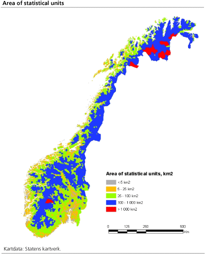
The figure shows all basic regional statistical units by total size of land and fresh water areas. Smallest units are located near the most populated areas.
Use and purpose of units
There are about 14 000 basic statistical units and 1 550 statistical tracts in Norway. The purpose of dividing the municipalities in basic statistical units was to establish small, stable and geographical units which can give a flexible basis for the work with and the presentation of regional statistics for statistical, analytical and planning purposes.
The basic statistical units are designed to be as stable as possible for a reasonable time period and the units shall be geographically coherent. One main principle is that basic statistical units shall be as homogeneous as possible with respect to, for example, communication and building structure.
The statistical tract is an intermediate level between municipality and basic statistical unit.
About the figures
Area of basic regional statistical units are based upon digital maps for administrative boundaries and calculated by the Norwegian Mapping Authority. Digital maps for administrative areas have been analysed with geographical overlay with digital maps for coastline, lakes and rivers.
Figures for land and water areas for municipalities and statistical units are available in the StatBank. Aggregation of area figures from different geographical levels may give slightly deviating sums. Deviations are mainly due to simpler area calculations of statistical units.
See
also
:
Database for standard classifications:
http://www3.ssb.no/stabas/ClassificationFrames.asp?ID=1498751&Language=en
National Mapping Authority:
http://www.statkart.no
For more information please contact :
Additional information
Contact
-
Erik Engelien
E-mail: erik.engelien@ssb.no
tel.: (+47) 91 12 55 45
-
Jørn Kristian Undelstvedt
E-mail: jorn.kristian.undelstvedt@ssb.no
tel.: (+47) 94 50 68 64