Content
Published:
This is an archived release.
2 per cent built-up area
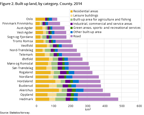
Of Norway's land area, nearly 2 per cent, or approximately 5 400 square kilometres is built up. Of this, land used for roads comprises the highest share. Hedmark is the county with the most built-up area, while the county of Oslo has by far the largest share of built-up area.
| 2014 | |
|---|---|
| Built up areas in total | 5 377 |
| Residential areas | 1 252 |
| Recreational facilities | 431 |
| Industrial, commercial and service areas | 421 |
| Transport, telecommunications and technical infrastructure | 2 234 |
| Built-up areas for agriculture and fishing | 539 |
| Other built up areas | 500 |


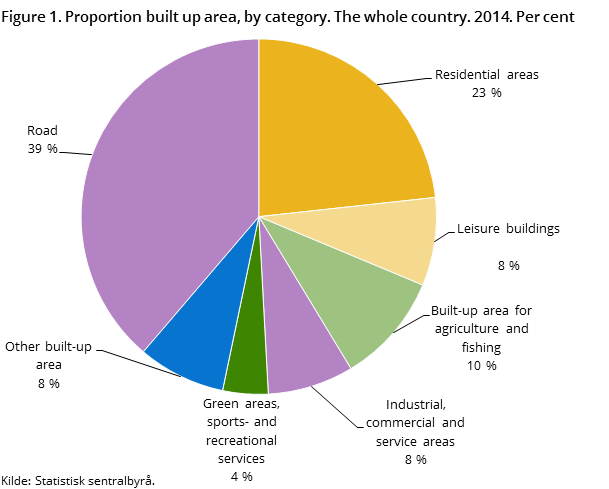
A new calculation of land use and land resources in Norway shows that land used for roads dominates the built-up area, with 39 per cent. In total, there is approximately 2 100 km2 of road area, which is close to the total area of the county of Vestfold. Residential area makes up 23 per cent of the built-up area, and leisure buildings account for 8 per cent.
Hedmark with the most built-up land
Hedmark has the most built-up area, while Oslo has the least built-up land use. As a percentage of the total area, the county of Oslo has the highest share of built-up land. The large amount of road area and agricultural buildings contribute to Hedmark’s placing at the top of the list. Akershus (135 km2) and Hordaland (115 km2) have clearly the most residential areas, while Sogn og Fjordane (29 km2) and Finnmark (24 km2) have the least residential area. Oppland has the largest area for leisure buildings; about 51 km2, followed by Buskerud with 46 km2.
Forest, mountain and moorland areas dominate
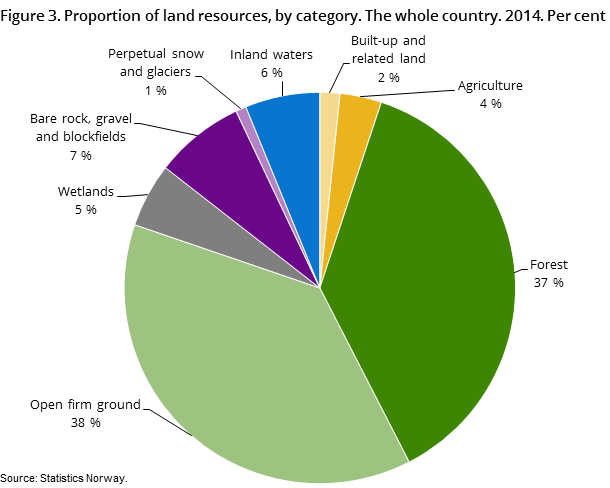
Looking at the total land area, about 2 per cent is built-up land, while agriculture represents some 3 per cent or 11 000 km2. Open firm ground dominates the non-built-up areas (38 per cent - 122 000 km2) together with forest (37 per cent - 121 000 km2).
Area covered by buildings and roads
A total of 520 km2 is covered by buildings (the buildings “footprints”), which is an increase of about 10 km2 per year since 2011.
The area covered by road surfaces (not counting road shoulders or ditches) is 1 150 km2.
Statistics based om mapsOpen and readClose
Norway's land should be managed so that natural and cultural environments, landscapes and important qualities of the environment are taken care of throughout the country. In addition, urban development should be based on planning principles that save land use and energy. Statistics showing the extent of land use and available land resources are a very important basis for decisions.
More detailed data sources have become available in recent years, which has provided the basis for comprehensive land use statistics for the country. Statistics Norway has established new, regular statistics on land use and land resources for the whole country based on register data (Cadastre) and digital map data that are classified according to an accepted statistical standard and processed using GIS (geographic information systems).
In addition to the Cadastre and chart data, the land resource map (AR-STAT) from the Norwegian Forest and Landscape Institute forms the most important foundation. AR-STAT forms the basis for the calculation of land resources in non-built-up areas and also partially delimits the built-up areas, but is overridden when other basic map data shows that the areas are built up.
Contact
-
Margrete Steinnes
E-mail: margrete.steinnes@ssb.no
tel.: (+47) 95 73 55 54
-
Jørn Kristian Undelstvedt
E-mail: jorn.kristian.undelstvedt@ssb.no
tel.: (+47) 94 50 68 64
